
Mapping Your Way Class 5 is Chapter 8 of the NCERT Mathematics textbook Math-Magic. In it, Ashi and her classmates watch the Republic Day parade at India Gate and, through the day, learn to read maps, scales and directions. The official NCERT chapter PDF is on this page, with every map and activity explained below.
Download the NCERT Mapping Your Way Class 5 chapter PDF
The NCERT Mapping Your Way Class 5 chapter PDF is the official NCERT file for Math-Magic Chapter 8 — open it to see the full-colour maps of Delhi, India and the five towns exactly as they are printed in the textbook.
What is inside the Mapping Your Way chapter
The table on this page lists what the chapter holds — sections, figures and question blocks — counted against the official NCERT PDF. The notes below describe what those sections do.
The chapter follows the parade day in order: Ashi reaches India Gate, the children match the helicopter photograph with Map 1, and the Central Hexagon question follows.
Then come the parade route on Map 3, Gappu’s Red Fort visit on Map 4, grid enlarging, the map of India with directions and scale, the sea and state borders, the five towns, and finally Ashi’s school seen from above.
What Mapping Your Way teaches: map reading through the Republic Day parade
Reading this chapter means reading its maps. Each stop on the parade day teaches one map skill:
- Match the map and the photo — compare the helicopter photograph with Map 1 and locate India Gate; find the same roads in both.
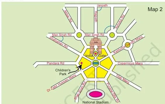
- The Central Hexagon — zoom into the map to see the six-sided yellow road block near India Gate.
- Find out from the map — compare pairs of roads by the angle between them and spot which pair cuts at right angles.
- Mark the route — trace the parade route from Vijay Chowk to Red Fort on Map 3 and estimate its length.
- Trip to Red Fort — walk through Lahori Gate, Meena Bazar and the Mughal halls on Map 4 and answer the Map 4 questions.
- Make It Bigger, Make It Smaller — copy pictures on 1 cm, 2 cm and \(\frac{1}{2}\) cm grids without changing their shape.
- Dancers from Different States — trace state routes on the map of India, with 1 cm = 200 km as the scale.
- The Sea and Lines between the States — find the sea, mark coastal states and read boundary lines.
- Distances between Towns and Ashi’s School — measure town routes in centimetres and kilometres, then count squares on the school plan.
The chapter has no separate exercise set at the end. Every question sits inside the activities above, so each skill is practised and tested in the same place.
Scale: what “2 cm = 1 km” means and how to convert map distances
Maps shrink a large real area to fit on paper. The chapter’s teacher note puts it plainly: when you show a big area on paper, you reduce it by one fixed ratio everywhere, so relative distances and positions stay the same. That fixed ratio is the scale.
| Scale | Map it belongs to | Conversion |
|---|---|---|
| \(2\ \text{cm} = 1\ \text{km}\) | Parade route, Map 3 | 5 cm measured \(\rightarrow 5 \div 2 = 2.5\ \text{km}\) |
| \(1\ \text{cm} = 100\ \text{m}\) | Red Fort, Map 4 | 4 cm measured \(\rightarrow 4 \times 100 = 400\ \text{m}\) |
| \(1\ \text{cm} = 200\ \text{km}\) | Map of India | 3 cm measured \(\rightarrow 3 \times 200 = 600\ \text{km}\) |
| \(1\ \text{cm} = 10\ \text{km}\) | Five towns map | 7 cm measured \(\rightarrow 7 \times 10 = 70\ \text{km}\) |
Worked example: measuring on the India map. Suppose a straight distance between two cities measures 4.5 cm.
- Step 1: Read the scale: \(1\ \text{cm} = 200\ \text{km}\).
- Step 2: Multiply the measured centimetres by 200: \(4.5 \times 200 = 900\).
Final answer: 4.5 cm on the map means \(900\ \text{km}\) on the ground.
The same scale line, \(2\ \text{cm} = 1\ \text{km}\), is printed on the parade map shown in the figure walkthrough below.
The Central Hexagon: shapes and angles between roads
Zooming in on a map means looking at one small part of it in more detail — the same idea a phone map uses. The chapter zooms into the area near India Gate and finds a yellow road block with six sides. A six-sided shape is called a hexagon, hence the name Central Hexagon.
The angle questions ask you to compare how sharply pairs of roads turn towards each other:
- Man Singh Road and Shahjahan Road;
- Ashoka Road and Man Singh Road, taking the angle away from India Gate;
- Janpath and Rajpath.
Find which pair makes the biggest angle, then which pair cuts at right angles. The biggest angle is about the turn between two roads — it is not about which road is longer.
Directions on the map of India: north, south, east and west
Directions tell you which way a journey moves, and on a map you read them from the map rather than guessing from memory. North is towards the top of the page.
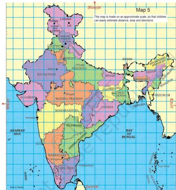
- The Karnataka team starts from Bangalore and moves in the north direction; trace the states it crosses to reach Delhi.
- Jammu and Kashmir is to the north of Delhi, so the team from there travels towards the south to reach Delhi; trace that route too.
- Nonu lives in Gujarat and his friend Javed lives in West Bengal. Gujarat is to the west, West Bengal to the east, so Nonu travels towards the east.
- The chapter also asks whether any state lies to the north of Jammu and Kashmir, and whether any state lies to the west of Gujarat. Trace both on the map: Jammu and Kashmir reaches the northern edge of the map, and the sea — not a state — is what you find to the west of Gujarat.
Tracing routes and measuring distances: parade route, Red Fort and the five towns
Three activities ask you to trace a path and measure it. Tracing means running your finger or pencil along the actual road line, including every bend. The parade route printed in Kancha’s newspaper is:
- Vijay Chowk
- Rajpath
- India Gate
- Tilak Marg
- B.S. Zafar Marg
- Subhash Marg
- Red Fort
Gappu’s Red Fort walk on Map 4 uses different landmarks: he enters at Lahori Gate, passes Meena Bazar and Naqqar Khana, reaches Diwan-e-Aam, then walks past Rang Mahal, Aaram Gah and Diwan-e-Khaas. The Map 4 questions locate these buildings — for example, which of Diwan-e-Aam or Diwan-e-Khaas is nearer the river Yamuna, and which building is farthest from Meena Bazar.
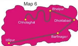
The five-towns activity asks you to measure the route between Bhelpur and Chholaghat with a thread. A route that bends cannot be measured straight with a ruler — the thread follows the curve, and then you lay the thread against the scale to read the real distance.
Enlarging and reducing maps on a grid without changing their shape
A grid is a pattern of equal squares drawn over a picture. The chapter gives pictures on a 1 cm grid and asks you to redraw them on a 2 cm grid and a \(\frac{1}{2}\) cm grid, keeping the shape identical.
Doubling the grid size makes every side two times longer — but the area does not double with it.
Worked example: draw a 3 by 2 rectangle on the 1 cm grid.
It covers \(3 \times 2 = 6\) unit squares.
- Step 1: On the 2 cm grid each side doubles, so the rectangle becomes 6 by 4.
- Step 2: Its new area is \(6 \times 4 = 24\) squares.
\[ 24 \div 6 = 4 \]
Answer: the area becomes 4 times bigger, not 2 times — both the length and the width doubled, so the area multiplies by \(2 \times 2 = 4\).
The same grid idea is applied to a part of the parade route map. The chapter then asks what the new scale would be if the India Gate–Vijay Chowk distance shrank to 2 cm — the point being that a smaller map carries a different scale.
The Find out activity: why different maps need different scales
A short Find out task asks you to compare the scales of a local area map, a map of India and a world map. They cannot use the same scale.
A local map shows a small area in detail, so a small ground distance occupies a large map distance; a world map squeezes the whole country into a few centimetres, so its scale is much smaller. Reading the scale first tells you how much detail to expect from any map.
The maps of Mapping Your Way, explained figure by figure
This chapter is built around maps and photographs, so its figures are not decoration — each one is something to decode. Work through them in the order they appear and one skill builds on the next.
Matching the photo and the map
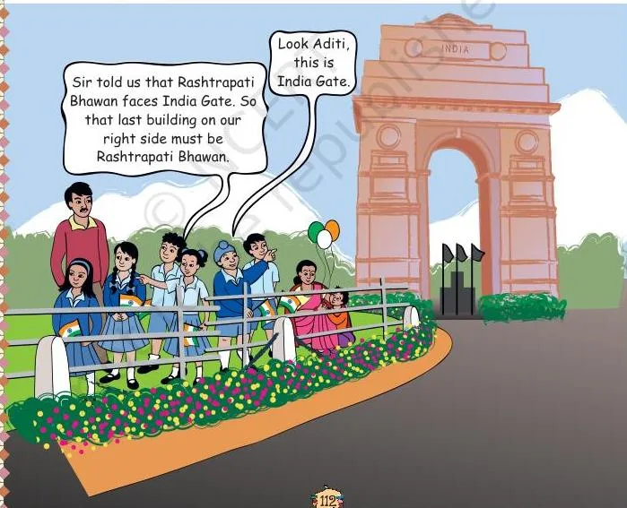
This opening picture sets the scene for the whole chapter: people line both sides of Rajpath, the road along which the parade passes. When the chapter asks you to mark where Aditi is on Rajpath, this is the road you locate.
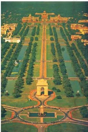
This is the same place seen from above. A helicopter photograph is an aerial view, and Map 1 is a simplified drawing of that view — which is why the first activity asks you to match the two and find India Gate. Use the photograph to spot the roads and the National Stadium, then find the same features on the map.
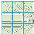
Zooming in shows a smaller area in more detail. Here the enlarged part of the map reveals the yellow Central Hexagon — six sides, so it is called a hexagon. Count the sides yourself; that is the chapter’s first question about it.
Scale and grids
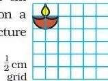
These pictures sit on a 1 cm square grid. The activity is to copy them on a 2 cm grid and a \(\frac{1}{2}\) cm grid so the outline keeps its shape — the same idea of a fixed ratio that maps use.
This line is the scale of the parade route map: \(2\ \text{cm}\) on the map stands for \(1\ \text{km}\) on the ground. Always read the scale before measuring, because every distance question in the chapter converts through this line.
The India map, the sea and state borders
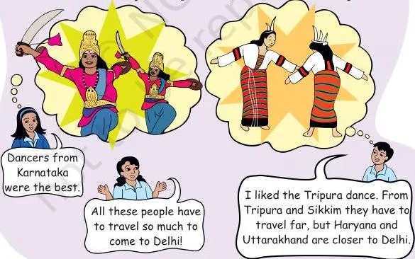
This photograph leads into the Dancers from Different States activity, in which children from Karnataka, Jammu and Kashmir and Gujarat describe their journeys on the map of India.
This is the map of India the chapter uses for directions and distance. Trace the Karnataka team’s route towards the north, the Jammu and Kashmir team’s route towards the south, and Nonu’s journey towards the east. Its scale, \(1\ \text{cm} = 200\ \text{km}\), converts map centimetres into ground kilometres.
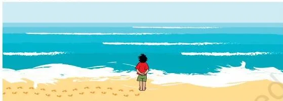
Bala stands where the land meets the sea. The activity asks you to find the sea on the map of India, notice the colour used to show it, mark the states that have the sea on one side, and name one state with no sea on any side.
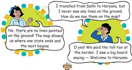
Sabu is puzzled by the lines drawn between states. Those lines are state boundaries — they show where one state ends and the next begins, and they help you answer questions like “which state is surrounded by four other states”.
The five towns and Ashi’s school
The five-towns map comes with the scale \(1\ \text{cm} = 10\ \text{km}\). Measure how many centimetres Idlipur is from Barfinagar, convert that to kilometres, mark the midway town Thukpagram, guess where Jalebipur could be, and use a thread for the bending route between Bhelpur and Chholaghat.
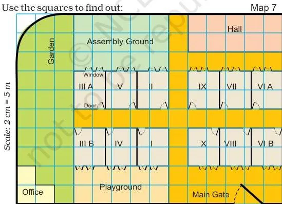
This is Ashi’s school seen from the top, drawn on a square grid. Because the plan uses equal squares, you can count squares to find how many times bigger the Assembly ground is than the office, and read each classroom’s length and width from the options given.
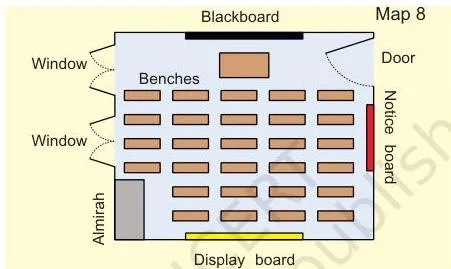
A classroom inside Ashi’s school: blackboard on the front wall, with almirah, windows, a notice board and a display board around it. The questions ask which item is exactly opposite the blackboard, and where each item would sit in the classrooms marked on the school plan.
Plain-language definitions for Mapping Your Way
The chapter has no printed glossary, so these meanings follow the way each word is used in the chapter.
| Term | What it means | Where it appears |
|---|---|---|
| Scale | The fixed ratio that tells how much the real area has been shrunk, such as 2 cm = 1 km. | Parade map, Red Fort map, India map, five towns map |
| Route | The path you follow from one place to another. | Mark the route (Vijay Chowk to Red Fort) |
| Central Hexagon | A six-sided road area, drawn in yellow, seen when you zoom into the map near India Gate. | The Central Hexagon |
| Grid | Equal squares (1 cm, 2 cm, \(\frac{1}{2}\) cm) used to copy, enlarge or reduce a picture without changing its shape. | Make It Bigger, Make It Smaller |
| Directions | North, south, east and west, used to describe which way a journey moves on the map. | Dancers from Different States |
Common mistakes in Mapping Your Way and how to fix them
| Mistake | Correct rule | How to check your answer |
|---|---|---|
| Estimating the parade route length without the scale | Every 2 cm on Map 3 stands for 1 km; convert before guessing. | Measure the route in cm, then divide by 2. |
| Thinking a doubled side doubles the area | Both length and width double, so the area multiplies by 4. | Count unit squares before and after. |
| Choosing directions from memory instead of the map | Trace the route on the map and name the direction you move. | Find Delhi first — J&K is north of it, so its team travels south. |
| Measuring a bent route with a ruler | Use a thread along the actual curve, then measure the thread. | Lay the thread against the scale line. |
| Picking the longest road when asked for the biggest angle | The biggest angle is the sharpest turn between two roads, not the longest road. | Compare the three pairs listed in the question. |
Worked check: 3 cm measured on the India map (\(1\ \text{cm} = 200\ \text{km}\)) means \(3 \times 200 = 600\ \text{km}\) on the ground — always multiply, never add.
Using the Mapping Your Way activities for revision
Because the questions sit inside the activities, the best revision is to work them in order. Each activity introduces one skill and immediately tests it, and each question is placed right beside the map it needs:
- Match the map and the photo — find India Gate on both.
- Find out from the map — compare angles at the Central Hexagon.
- Mark the route — trace and estimate the parade route on Map 3.
- Find out from Map 4 — locate the Red Fort buildings.
- Make It Bigger, Make It Smaller — redraw on 2 cm and \(\frac{1}{2}\) cm grids.
- Dancers from Different States — trace routes and use 1 cm = 200 km.
- The Sea and Lines between the States — coastal states and borders.
- Find out — compare the scales of different maps.
- Distances between Towns — measure with the 1 cm = 10 km scale.
- Ashi’s School — count squares on the top-view plan.
Keep the scale visible while you work and state it in every answer that gives a distance. Textbook contents and the examinable syllabus are not always identical — check the current official syllabus for what is examinable this year.
What to remember from Mapping Your Way
The chapter closes with activities rather than a printed summary, so this quick table is built from those activities in our own words.
| Skill | Where the chapter uses it | Quick check |
|---|---|---|
| Reading a map with landmarks | Matching the photo with Map 1 | Point to India Gate on both. |
| Converting distances with a scale | Parade map, India map, five towns | Multiply map cm by the scale value. |
| Giving directions between states | Dancers from Different States | J&K is north of Delhi, so its team goes south. |
| Enlarging on a grid and predicting area | Make It Bigger, Make It Smaller | Doubling the side quadruples the area. |
| Tracing and measuring a route | Five towns, parade map | Use a thread for a curve, then the scale. |
Other Class 5 Math-Magic chapters to use with Mapping Your Way
Mapping Your Way sits between two shape-and-space chapters in Math-Magic. The previous chapter, Can You See the Pattern?, practises the shapes and symmetry that the Central Hexagon builds on, and the next chapter, Boxes and Sketches, uses the same top-view drawing idea as Ashi’s school plan.
For the rest of the book, open the Class 5 Mathematics notes hub, or browse all Class 5 study material and the CBSE notes home page.
Sources and data verification
This listing is maintained for the 2026-27 academic session using the NCERT textbook information available to us. NCERT remains the authority for confirming the latest edition.
The description on this page follows the NCERT Class 5 Mathematics textbook, Math-Magic, Chapter 8 (Mapping Your Way), official edition on ncert.nic.in. NCERT settles textbook editions and their PDFs; CBSE settles the curriculum, syllabus and examinations.
This page is maintained for the current academic session using the NCERT information available to us, and it covers only this chapter of Math-Magic — not the full CBSE scheme of studies.
| What the chapter holds | Count | Where it is used |
|---|---|---|
| Printed pages | 14 | |
| Figures with NCERT captions | 12 | |
| Activities | 1 | |
| Official NCERT PDF | Download the chapter PDF | the chapter exactly as NCERT publishes it |
Reference: NCERT Class 5 Mathematics textbook (Math-Magic), chapter 8, official edition on ncert.nic.in.
Frequently asked questions about Mapping Your Way Class 5
What does the scale 2 cm = 1 km mean in the parade route map of Mapping Your Way?
It means every 2 cm you measure on the map stands for 1 km on the real ground. To convert, measure the route in centimetres and divide by 2 — a 6 cm measurement means 3 km.
Why is the area four times bigger when I draw the same picture on a 2 cm grid instead of a 1 cm grid?
Because each side doubles. Area is length multiplied by width, so doubling both multiplies the area by \(2 \times 2 = 4\). A shape covering 6 unit squares covers 24 on the 2 cm grid.
How do I estimate the distance between Delhi and Jaipur using the map of India scale in this chapter?
Measure the gap between the two cities on the map, then multiply by 200 because 1 cm = 200 km. The map reading gives about 250 km, which matches option (c) in the chapter.
Is there any state to the north of Jammu and Kashmir in the NCERT map?
Trace upwards from Jammu and Kashmir on the map of India and you reach the northern edge of the country — no Indian state lies beyond it, so the answer is none.
Why does the chapter ask me to measure the route from Bhelpur to Chholaghat with a thread?
Because the route bends. A ruler measures straight lines only and would give a length shorter than the real road; a thread follows every curve, and you then measure the thread against the scale (1 cm = 10 km).
Where are the exercise questions in NCERT Class 5 Mapping Your Way?
There is no separate exercise block at the end of the chapter. All questions are embedded in the map activities — Match the map and the photo, Find out from the map, Mark the route, Find out from Map 4 and the rest — so each question sits right beside the map you need to answer it.
Explore Class 5 Mathematics Books
- Previous: Shapes and Patterns
- Next: Boxes and Sketches
Related chapters: